The government has asked residents of Kibera and 5 other downstream estates to evacuate immediately over fears that the Nairobi Dam will break its banks.
The Water Resources Authority (WRA) warned that rising water levels in the reservoir pose an imminent risk of flooding due to a potential breach of the dam’s embankment.
“Due to the ongoing heavy rains, residents living downstream of Nairobi Dam are warned of imminent flood risk due to the rising water levels in the reservoir that threaten breaching of the dam embankment," the notice signed by Noel Ndeti, WRA’ Subcounty Coordinator states.
Consequently, residents of the Kibera area, Nyayo Highrise, Dam Estate, Lang'ata, Nairobi West, and Madaraka are to evacuate immediately to higher ground.
“Everyone living/operating downstream of the dam is cautioned to be vigilant and relocate to higher grounds,” the notice added.
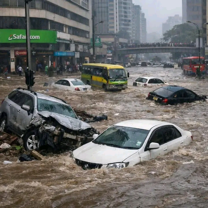
The Kenya Meteorological Department says heavy rainfall exceeding 20mm in 24 hours is expected from March 19 to 24, across several parts of the country.
Government spokesman Isaac Mwaura had in the past revealed the the state was monitoring the dam while conducting technical assessments of the reservoir to determine the potential risks posed by rising water levels.
"The government is closely monitoring the rising water levels at Nairobi Dam and advises residents living downstream to remain alert. A technical assessment of the dam is currently underway," Mwaura stated.
Last week, the state mapped 37 areas that are pyrone to flooding as heavily rains continue to pound the country causing damages that include paralysing transport among major highways.
According to the ministry, a mapping exercise conducted under the Nairobi Rivers Regeneration Programme identified the 37 neighbourhoods located along major river corridors and locations vulnerable to flooding.
In Nairobi East, the areas identified include Kiambiu, Dandora, Kariobangi, Kayole, Komarock, Njiru, Ruai, Mwiki, Donholm, Savannah, Tassia, and Fedha.
In addition, flood-prone areas in Nairobi West include Madaraka, Nairobi West, Lang’ata, Kawangware, Kangemi, Lavington, Westlands, Parklands, Kitisuru, Spring Valley, Kileleshwa, and Chiromo.
In the Nairobi North corridor, neighbourhoods such as Mathare, Korogocho, and Lucky Summer have been identified along the Mathare River, where dense settlements closely border the river banks. Within Nairobi Central, key locations along the river corridor include the Central Business District (CBD), Globe, Gikomba, Eastleigh, and the Industrial Area.
In Nairobi South, the mapping highlights Kilimani, Kibera, South C, South B, Mukuru Kwa Reuben, and Kwa Njenga, many of which lie along the Ngong River corridor.


Comments 0
Sign in to join the conversation
Sign In Create AccountNo comments yet. Be the first to share your thoughts!