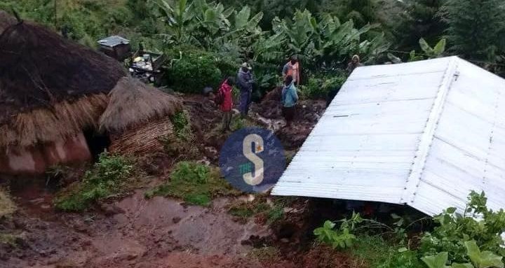
 Severe effects of the mudslides that have wreaked havoc along homes and farmlands in Elgeyo Marakwet/FILE
At least 18 people have died following mudslides triggered by ongoing heavy rains across parts of the country, the National Police Service has confirmed.
The fatalities, reported as of May 3, come amid sustained rainfall that has heightened disaster risks in several regions.
Police said mudslides have struck Tharaka Nithi County, Elgeyo-Marakwet County and Kiambu County, leaving families displaced and causing extensive damage to homes, infrastructure and livelihoods.
Police described the situation as dire, warning that the continuing downpour poses a serious threat, particularly in landslide-prone and flood-affected areas.
Multi-agency teams have been deployed to the affected regions, where they are conducting search and rescue operations, evacuating residents from high-risk zones and distributing emergency relief supplies.
Ongoing assessments are also being carried out to identify vulnerable areas and prevent further loss of life.
Despite these efforts, police have urged Kenyans to exercise extreme caution and remain alert as weather conditions remain unpredictable.
Emergency response lines, including 999 and 112, remain operational, while members of the public have also been encouraged to report incidents through the #FichuaKwaDCI platform.
The National Police Service said it remains on high alert and reaffirmed its commitment to protecting lives and property.
NPS said that close coordination between communities and response agencies will be critical in averting additional casualties.
On Sunday, the government mapped 59 flood-prone areas across Tana River county, amid rising concerns over increasing water levels along the Tana River.
According to the latest assessment, Tana Delta Subcounty has the highest number of at-risk areas at 32, followed by Tana River Subcounty (10), Bangale (8), Tarasaa (6), and Tana North (3).
The mapping comes in the wake of alerts linked to swelling water levels from the Seven Forks Dam, raising fears of widespread flooding downstream.
The situation in Tana River mirrors a broader national crisis, with 18 flood-related deaths recorded across the country as of May 2, 2026, most caused by drowning.
The Eastern Region has reported the highest fatalities (9), followed by Central (3), Coast (2), Nairobi (2) and Rift Valley (2).
In Nairobi, flooding has affected an estimated 6,600 people, displacing families and damaging roads, schools, and homes across several sub-counties.
Counties in the Central region, including Kirinyaga County and Kiambu County, have reported extensive destruction of infrastructure, including roads and bridges. In Mwea West, about 3,000 residents have been displaced.
In Eastern Kenya, Makueni County recorded the highest number of fatalities, with flash floods and mudslides destroying homes and damaging roads and power lines.
Low-lying areas in Tana Delta Subcounty identified as highly vulnerable include Feji, Kiembe, Halubha, Sera, Bwoka, Tsanankuu, Godhey, Dobaley, Abaganda, Salama, Ndera, Wema, Galili, Chira, Bilisa, Shirikisho, Kipini, Miliki, Majaliwa, Onido, Ndiponi, Kau, Kilelengwani, Kalota, Pungaupepo, Kidhanga, Diribu, Magogoni B, Kajisten, Ndimimbii, Ribe A, and Ozi Mtangani.
Other affected areas include:
Tana River Subcounty: Masabubu, Rhoka, Kinakomba-Boji, Emmaus, Watta Hamesa, Vukoni, Mkomani, Bondeni, Laza-Makaburini, Makere
Bangale Subcounty: Bowa, Mbalambala, Mororo, Saka, Madogo, Tula, Ziwani, Bulto Banta
Tana North Subcounty: Bura, Chewele, Hirimani
Tarasaa Subcounty: Kipao, Ongonyo, Odole, Konemansa, Kigomo, Manono.


Comments 0
Sign in to join the conversation
Sign In Create AccountNo comments yet. Be the first to share your thoughts!