
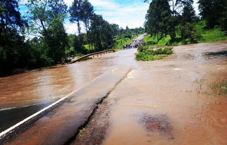
The Kenya National Highways Authority (KeNHA) has temporarily closed the Kaplong-Kisii road after floodwaters submerged a section of the highway at the Kipsonoi River Bridge at Mugeni.
In a traffic advisory issued March 7, KeNHA said rising water levels at the bridge, located between Sotik and Chebilat, had overtopped the structure, making it unsafe for motorists to cross.
“The Kenya National Highways Authority has closed the Kaplong-Kisii Road following flooding at the Kipsonoi River Bridge at Mugeni,” the authority said in the statement.
According to KeNHA, the flooding was caused by heavy rainfall in upstream catchment areas, which resulted in a significant surge in water levels along the Kipsonoi River.
“Rising water levels have overtopped the bridge, rendering passage unsafe for motorists,” the statement said.
Motorists have been urged to strictly follow instructions from traffic police and road marshals deployed to the area to manage traffic and prevent accidents.
KeNHA also advised drivers to use alternative routes while authorities monitor the situation and work to restore normal traffic flow.
Motorists travelling to Chebilat and Keroka have been advised to use the Kaplong–Sotik–Roret–Ikonge–Chebilat–Keroka route.
Those heading to Kisii have been advised to use the Kaplong–Sotik–Roret–Ikonge–Kisii road.
“Motorists using this route are advised to use the alternative routes provided and follow the instructions of police and traffic marshals to prevent any accidents,” the authority said.
KeNHA Director-General Luka Kimeli said the agency is working to ensure the safety of motorists and restore traffic movement along the affected section.
“KeNHA assures all road users that it is working around the clock to restore normal traffic flow and ensure the safety of motorists,” Kimeli said.
The closure comes amid ongoing heavy rains affecting several parts of the country, which have triggered flooding in low-lying areas and along major rivers.
The Kenya Meteorological Department (KMD) has said theheavy rainfall across the country is set to continue through the weekend and into early next week, with isolated storms measuring between 40mm and 100mm in some areas.
In a statement released March 7, Acting Director of Meteorological Services Edward Muriuki said the ongoing rainfall has already caused significant disruptions.
“The current wet spell has saturated soils and overwhelmed drainage systems in many parts of the country, raising the risk of floods, landslides, and water contamination,” he noted.
Parts of Nairobi, including Westlands, Dagoretti, Embakasi, Kibra, Roysambu, and Kasarani, have been particularly affected, alongside Kiambu, Kajiado, Machakos counties, and regions in Western Kenya, the Rift Valley Highlands, and the Coastal areas.
“In Dagoretti alone, 112.2mm of rainfall was recorded in 24 hours, while Wilson Airport recorded 160mm,” said Muriuki, highlighting the scale of the downpour.
Residents are being urged to exercise caution, especially in low-lying areas and near rivers.
“Twenty millimeters of rain per square meter can quickly saturate the soil and flood roads. We advise people to avoid walking or driving through moving water and to stay away from riverbanks,” he warned.
The KMD listed areas expected to experience continued heavy rainfall, including the Lake Victoria Basin (Busia, Kisumu, Homa Bay, Migori, Siaya), the Rift Valley Highlands (Nandi, Kericho, Nakuru, Uasin Gishu, and others), the Central Highlands including Nairobi, the Southeastern lowlands (Machakos, Kajiado, Makueni, Kitui, Taita Taveta), and the Coastal region (Kwale, Mombasa, Kilifi).
“This prolonged wet spell started in mid-February 2026 and has left soils saturated, increasing flood risks in many areas,” Muriuki added.
The KMD reassured the public that it will continue to monitor the situation closely, providing timely updates to support preparedness and response efforts.
Residents are advised to heed all warnings, avoid flood-prone areas, and stay alert as the rains continue.
Emergency services and county authorities have been urged to remain on high alert to mitigate potential impacts on communities, infrastructure, and livelihoods.
The rains which pounded Nairobi on Friday evening have led to floods, with deaths and damage to property reported.
Police have confirmed that 25 have died as a result.
The most affected areas include Mukuru, Kibra, Mathare, Huruma, South B and C, Pipeline/Embakasi, Roysambu, Kahawa West, Githurai, and parts of Westlands.
Key highways such as Uhuru Highway, Mombasa Road, the Thika Superhighway, Jogoo Road, Enterprise Road, and Lang’ata Road have also been impacted, with some sections impassable due to rising waters.
In response, the NPS launched immediate search and rescue operations overnight, working alongside other stakeholders to reach people trapped by the floods.


Comments 0
Sign in to join the conversation
Sign In Create AccountNo comments yet. Be the first to share your thoughts!