
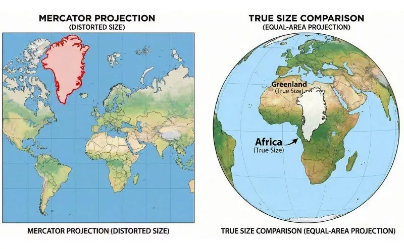
Spearheaded by Togo with the support of the African Union, the resolution encourages cartographic practices that more accurately reflect the true sizes of continents and regions, particularly Africa, and marks a global endorsement of The Equal Earth Map, originally developed in 2018.
For more than four centuries, much of the world has learned geography through the Mercator projection, a map created in 1569 by cartographer Gerardus Mercator to help sailors navigate oceans. It was a remarkable innovation making maritime travel significantly easier. But somewhere along history's journey, this navigation tool became the world's educational map. The exception gradually became the global baseline.
For generations, we have encountered the same familiar projection hanging in classrooms, printed in atlases and embedded in digital platforms. Long before children understand how the world works, they learn where countries appear, how large they seem and which parts of the world dominate the page. A map becomes one of the earliest lessons about the world.
We rarely questioned why Greenland appears comparable in size to Africa, when Africa is roughly fourteen times larger. The African continent, home to more than 1.5 billion people and 54 sovereign states appears compressed. Over time, familiarity transformed these distortions into something that felt natural.
A historical choice becomes so widely repeated that it begins to feel universal rather than constructed. Maps are only one example.
This is what many African diplomats and scholars describe as the symbolic minimisation of Africa and other equatorial regions. A widely used visual representation understated Africa's true scale and, in so doing, helped perpetuate an unbalanced mental picture of the world.
The UN resolution itself acknowledges that commonly used projections have contributed to diminished perceptions of Africa and other equatorial regions, when it comes to education, culture and public understanding.
For many countries across Africa, the resolution resonates beyond cartography because it reflects a broader conversation about representation in international affairs.
The Global South has often been described through reference frameworks created during different historical eras. Terms such as ‘developing world’ and ‘emerging markets’ became shorthand for describing countries with different economic trajectories, governance structures or historical experiences. These categories shape narratives about influence, stability and opportunity.
Maps became part of that inherited narrative.
None of these terms are malicious as they emerged from historical technologies or political realities. Understandably, terminology is useful for experts like economists and policymakers who need these categories and indicators. But when do these historical examples start fairly representing the world in consideration of equality, especially where the Global South is concerned?
The Equal Earth Map offers something symbolically different. It allows countries in the Global South to be viewed from the same geographic footing as every other region. Not enlarged, not diminished, simply represented in their true proportion. Equality often begins with equal representation.
It also arrives at a moment when Africa's role in global affairs is changing rapidly.
Africa occupies nearly 20 per cent of the earth's landmass, is home to the world's youngest population with a median age of around 19 years, and by 2050 one in every four people on Earth is expected to live on the continent.
It is increasingly central to global conversations about energy, technology, manufacturing, minerals, food security and demographic growth. Yet international narratives have often portrayed Africa as defined by aid rather than innovation, crises rather than capability and potential rather than influence.
An accurate map can ensure that the visual language used to describe the world, better reflects the countries’ actual place within it.
Perhaps the most remarkable part of the resolution was the scale of support behind it.
For an issue touching on history, education and global representation, that level of support is striking and it shows that a broad section of the international community considered the conversation legitimate and timely.
The resolution is already beginning to move from symbolism to implementation. Togo has announced plans to replace Mercator-based maps in its school geography curriculum before the end of the year, while Togo’s Foreign Minister Robert Dussey has said the country will work with AU member states, international organisations and technology companies to encourage wider adoption of The Equal EarthMap projections.
AU has similarly pledged to collaborate with governments, publishers and digital platforms to promote more accurate representations of the world.
These developments suggest this is not simply about replacing one map with another. It is about updating the visual language through which future generations understand the world. Accuracy is a form of equality. Quite significant for the Global South.
The first step towards a more equal world is simply learning to see it on equal terms.
Editor, China Media Group Africa